
I-Hsien Porter
One of the most instantly recognisable paintings in the world is Leonardo da Vinci’s Mona Lisa. Painted in the early sixteenth century, the many ambiguities in the picture – the identity of the subject, the subject’s expression – have led to continuing fascination with the work.
Recently, an Italian art historian claimed to have identified the location of the painting. A bridge, with a reference to the date of a devastating flood, was spotted in the background. Art historian Carla Glori believes that this ties the image to a specific place on the River Trebbia, Italy.
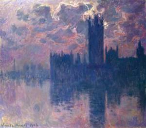
In a paper in Area, Soraya Khan and others examine Monet’s London Series of paintings. The position of the Sun in the paintings, along with the knowledge of the exact location of the paintings (from London landmarks), was used to date the images.
This form of historical dating opens an opportunity for interdisciplinarity between human and physical geography. In environmental studies, the artist’s depiction of the atmosphere gives insights into the physical climate of London. Likewise, art also offers insights into the social mood of the time.

Khan, S. et al. (2010) “Monet at the Savoy.” Area 42 (2): 208-216
The Daily Telegraph (10th January 2011) “Mona Lisa landscape location mystery ‘solved’.”

While things like this make it easy to see the geographic aspects of art. I see so much art in geography, things as simple as maps. I’d love to see a graphic designer take map art to a new level. I might just have to invest in CS5 and do it myself. 🙂