
By Doug Specht, University of Westminster
There are currently 32 active conflicts raging around the world. While bullets and bombs are the immediate instruments of destruction, maps also play a significant role in shaping conflict.
Maps, although apparently objective representations of terrain, can be twisted into instruments of dehumanisation and strategic manipulation, fuelling the flames of conflict. Maps have played an especially cruel role in the creation and now destruction of Gaza.
Palestine was drawn on a map at the end the First World War. The portion of the territory that lies west of the River Jordan was also known as the land of Israel by people of Jewish heritage.
The victorious allied powers assigned Britain to administer Palestine in 1922, and entrusted it with establishing in Palestine ‘a national home for the Jewish people’, so long as doing so did not prejudice the civil and religious rights of non-Jewish communities
In 1947, Britain relinquished its responsibility and handed the region to the UN who divided the territory. A year later, when the British Mandate officially ended, the Jewish leadership in Palestine declared the establishment of the State of Israel – but without defining its borders.
Ongoing conflict, occupation and politics have seen borders continue to move and territories change hands. These changes have been well documented on maps. Yet these maps also aid in the process of creating the conditions for ongoing violence and human tragedy.
Passive dehumanisation

Map makers have a very small range of tools at their disposal to depict the world: lines, points and colours. With these tools, skilled cartographers can provide us with a view of the world so real, so accessible and often so beautiful that they lure us into seeing a world that is oversimplified.
Lines on maps are used to show us borders of countries, denoting a change from control of one party on one side, to control of another on its opposite. All things on one side of a line are the same. And everything across that line is different.
In mapping wars, the idea that everything on the other side of a line is different acts to dehumanise those on the side that is not ‘ours’. On our side of the line, everything is known. And the other side is, in effect, blank space. It is perhaps shaded one colour or another, but ultimately it is blank.
In war, these neat lines mask human atrocity, destruction and pain. They sanitise conflict and make it easy for armchair generals, both those with medals on their chests and those on X (formerly Twitter), to make sweeping statements on behalf of populations.
The maps used in the media to help us understand the ongoing conflict in Gaza show us contested lands, ill-defined borders and territory to be fought over. But they hide more than 30,000 lives that have been extinguished, 70,000 injured and the endless trauma of bombardment, bereavement and starvation. Efforts to be more explicit about human suffering have been made, with some excellent work from Reuters. While Reuters’ detailed briefing on the conflict is well crafted as a whole, many of the maps produced still float Gaza in a no-mans-land, without geographical context, making them harder to read when taken out of their surrounding text.
Active dehumanisation
Maps also play an active role in dehumanising others, making it easier to view humans and their ways of life as targets of military action. Maps take a messy, complicated world and turn it into a flat picture.
Military maps are all about what’s strategically important. They show things like enemy bases and supply routes with big, bold colours. Innocent people living their lives don’t get much attention on these maps, and that can make it easy to forget they’re even there.
Maps are also filled with symbols and not people. For example, soldiers on maps are just dots or icons, like little tanks or flags. This can make them seem a faceless enemy instead of individual people with feelings and families.
The Israel Defence Force’s introduction of grid maps in December 2023 takes this dehumanisation further. Israel has divided Gaza into more than 600 blocks, ostensibly to aid in evacuating civilians. Each block on the map can receive evacuation warnings before the bombardment of a given square.
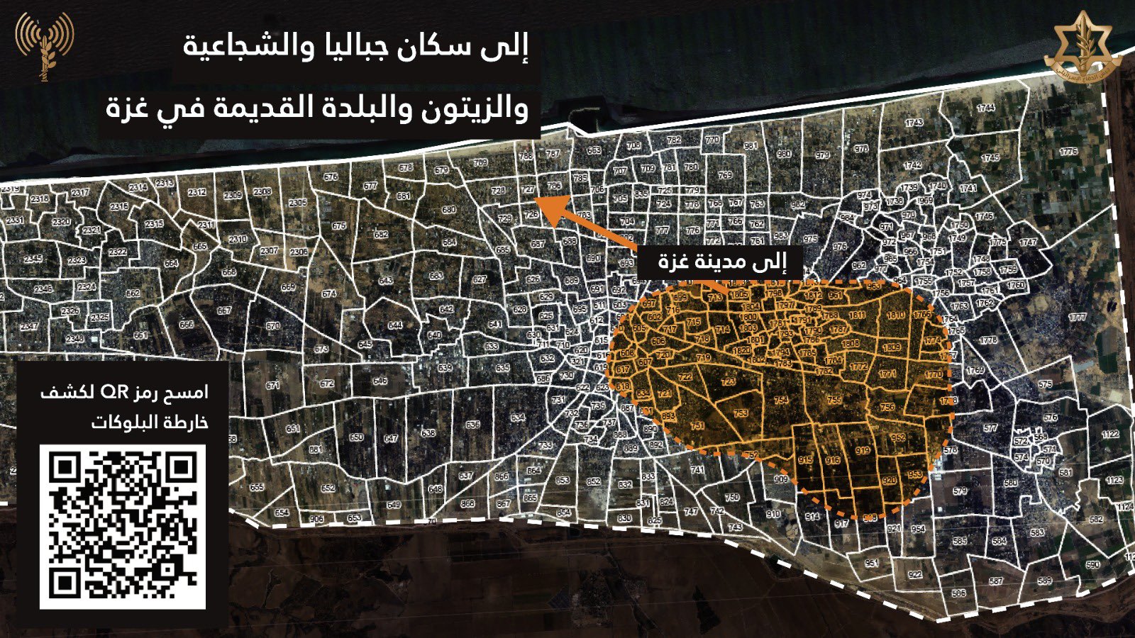
However, the online map is inaccessible to most people in Gaza due to the destruction of telecommunications infrastructure and power outages. Even when the map is accessed, instructions on where to flee are confused, do not correlate to bombardments, or send civilians to areas with few or no resources. This makes it ineffective as a tool for evacuations or preserving civilian life.
The map now acts like a horrific game of battleships, in which the flattening of any grid square is justified under the pretence that it is an empty space on a map. Gaza is no longer a place filled with human life, but rather it is a map of zones to attack.
The power of maps
Maps have the power to construct and reinforce certain realities while omitting or distorting others. Cartographers make decisions about what to include or exclude, how to symbolize features, and which narratives to prioritize, all of which can shape the way we perceive the world around us. In conflict, this means maps can be easily weaponized to serve political agendas or perpetuate false narratives, exploiting their perceived authority to lend legitimacy to distorted versions of reality.
Maps are now easier than ever to produce, with individuals and organizations creating and disseminating maps with unprecedented ease. Easier and cheaper mapping tools have led to greater accessibility and diversity of perspectives and have allowed for a great deal of counter-cartography projects that help us to gain a deeper understanding of conflict. Projects such as those by Forensic Architecture, or even Bloomberg, help to challenge some of the narratives around Gaza, holding politicians to account.
However, in conflict, for every attempt to reveal truth, there is an attempt to create an alternative truth. The ease with which maps can be produced has also raised concerns about the proliferation of misinformation and the manipulation of spatial data. In a post-truth landscape where anyone can create and share maps online, the line between fact and fiction becomes increasingly blurred, and the role of critical thinking becomes paramount. The democratization of mapmaking highlights the need for media literacy and digital literacy skills to navigate the complex and often deceptive terrain of modern cartography, where maps can simultaneously inform, mislead, and shape public opinion – often without the questioning that images or text invite.
Maps are still seen by many as representing objective truth. We turn to maps for certainty and knowledge, yet the world is in flux and maps show us what we cannot immediately experience or verify. Maps exercise our faith by encouraging us to believe what we cannot see.
But if we are lured into a belief that a map serves only the purpose of showing us a scientific, accurate and true vision of the world, then we are destined to always be deceived. This will first be by the map maker, and then by those who seek to influence the way in which we each fill the maps with stories.
About the author: Doug Specht is a Reader in Cultural Geography and Communication at the University of Westminster. He is also a Chartered Geographer of the Royal Geographical Society.
Suggested Further Reading
Agha, Z., Esson, J., Griffiths, M. & Joronen, M. (2024) Gaza: A decolonial geography. Transactions of the Institute of British Geographers. Available from: https://doi.org/10.1111/tran.12675
A., & Buckley-Zistel, S. (Eds.) (2016). Spatialising peace and conflict: mapping the production of places, sites and scales of violence. Palgrave Macmillan, London. Available from: https://doi.org/10.1057/9781137550484
Gregory, D. (2015) Gabriel’s Map: Cartography and Corpography in Modern War. In: Meusburger, P., Gregory, D., Suarsana, L. (eds) Geographies of Knowledge and Power. Knowledge and Space. Springer, Dordrecht. Available from: https://doi.org/10.1007/978-94-017-9960-7_4
Specht, D. (2024) Mapping the Unmappable: Cartography at war. LivingMaps Review. Available from: https://www.livingmaps.org/mapping-the-unmappable
Specht, D. (2020) Mapping Crisis: Participation, Datafication, and Humanitarianism in the Age of Digital Mapping. University of London Press, London. Available from: https://doi.org/10.14296/920.9781912250387
Tarvainen, A. & Challand, B. (2023) Innovation as erasure: Palestine and the new regional alliances of technology. Transactions of the Institute of British Geographers. Available from: https://doi.org/10.1111/tran.12663
How To Cite
Specht, D. (2024, April) Gaza war: how maps are used and abused in times of conflict. Geography Directions. https://doi.org/10.55203/VZSD7618
