

By Eugenio Mincione, LMU Munich
When Spain runs short of water, the pictures are always the same: cracked reservoir beds, church towers rising out of empty lakes, water lorries driving into thirsty towns. They tell a story about rain, or the lack of it. But some of Spain’s most serious water losses cannot be photographed at all. They are happening underground, and they follow a pattern that has less to do with the weather than with who is allowed to pump.
The challenge: an overdraft no one can see
Beneath Spain lie hundreds of aquifers: layers of rock, sand and gravel that hold water like a sponge. Rain and rivers slowly refill them, while wells and boreholes draw them down. As long as the two are in balance, an aquifer can supply farms and towns for centuries. When more is pumped out than flows back in, the water table falls, springs dry up, and wetlands that depend on groundwater begin to die.
Under EU law, every member state has to check its groundwater regularly and report the results. For this purpose, Spain divides its underground water into 804 management units, known as groundwater bodies. In the current river basin plans, which run from 2022 to 2027, 203 of them are officially classed as over-pumped: one in four. According to the European Commission’s assessment of Spain’s plans, this share has not improved since the previous round of plans six years earlier.
A national figure like this hides more than it reveals. So I asked a geographical question instead: where are these aquifers, and what is draining them?
The geographical contribution: a map of who pumps
To answer it, I mapped the official data that Spain itself reports to the European Environment Agency: the outline of every groundwater body, its status, and the pressures the authorities have recorded for it.
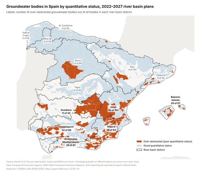
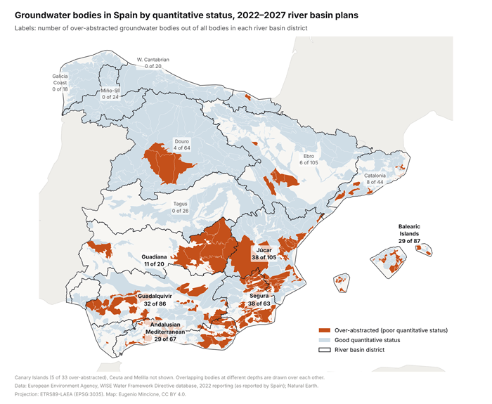
Over-pumped (“over-abstracted”) groundwater bodies, shown in orange, in Spain’s river basin districts, 2022–2027 plans. Map: Eugenio Mincione, CC BY 4.0. Data: European Environment Agency, WISE Water Framework Directive database, 2022 reporting.
The result is a strikingly uneven geography. Six river basins in the south and east (the Segura, Júcar, Guadalquivir and Guadiana, the Andalusian Mediterranean basins and the Balearic Islands) contain 177 of the 203 over-pumped groundwater bodies, or 87 per cent. Yet together they cover only 39 per cent of Spain’s land area. In the Segura basin around Murcia, 38 of 63 groundwater bodies are over-pumped, and they lie beneath more than a third of the basin. By contrast, the wet north-west and the Tagus basin, which sends water south through a transfer almost 300 kilometres long, have none at all.
The second finding concerns cause. For 182 of the 203 over-pumped bodies, or 90 per cent, the river basin authorities themselves list pumping for agriculture as a significant pressure. This is not an accusation from outside. It is what Spain’s own water managers have written into their plans.
The map also points to who pays. Almost half of the over-pumped bodies (97) feed wetlands, springs or riverside forests that depend on groundwater. The best-known example is Doñana, the great wetland near Seville and a UNESCO World Heritage Site. A synthesis by more than twenty scientists finds that groundwater levels in its deep aquifer have fallen by up to 20 metres and that the flow of its main stream has dropped by 62 per cent. In 2021 the Court of Justice of the European Union ruled that Spain had failed to protect it. Santa Olalla, its largest permanent lagoon, dried out completely in 2022 and 2023, and again in 2024: the third summer in a row.
Why efficiency has not solved it
Spain has not ignored the problem. For two decades, its main answer has been technology. Between 2002 and 2015, public programmes helped convert 1.79 million hectares from open channels and flood irrigation to pipes and drip systems. On each field, this saves water: modernised farms apply roughly a third less.
Across a whole river basin, the picture looks different. Water that once leaked from old channels flowed back into rivers and aquifers, where others used it again. When farmers save water on the field but keep their water rights, the “saved” water is often used to irrigate more land or to grow thirstier crops. Researchers call this the paradox of irrigation efficiency. A review of the international evidence concludes that efficient technology on its own should not be treated as a way of saving water. If the aim is to leave more water in nature, water has to be actively reallocated.
This is where geography matters. The over-pumped aquifers lie in the same dry basins where irrigated farming has expanded most, much of it growing fruit and vegetables for export to the rest of Europe. Scarcity in these regions is not only a fact of nature. It is also the outcome of decisions about how much land a dry basin can irrigate, which wells are tolerated, and whose losses count.
Take-home messages
- Scarcity is made as well as given. Climate change will make Spain’s south and east drier. But in nine out of ten of the aquifers in trouble, the authorities themselves name farm pumping as a cause. Less rain explains part of the problem; how much is pumped explains the rest.
- Saving is not the same as giving back. More efficient technology makes farming more productive. It only helps aquifers and wetlands if the water it saves is formally returned to them, for example by reducing water rights when modernisation is publicly funded.
- Making overdraft visible is the first step. Water meters on wells have been required by law since 2009, but the European Commission reports that they are still not installed everywhere and that illegal pumping remains a significant, poorly controlled pressure. Public data on who pumps how much would turn an invisible problem into a political one.
Spain will not run out of rain. Whether it runs out of groundwater depends on who is asked to give way first, and on whether the answer is, once again, the wetland.
About the author: Eugenio Mincione studies geography (geoinformatics) and political science at LMU Munich and is currently on an Erasmus exchange at the Universidad de Alcalá in Madrid. He edits UNEVEN, an independent magazine on the geography of inequality.
Suggested further reading
De Stefano, L., Fornés, J. M., López-Geta, J. A. and Villarroya, F. (2015). Groundwater use in Spain: an overview in light of the EU Water Framework Directive. International Journal of Water Resources Development. Available from: https://doi.org/10.1080/07900627.2014.938260
Grafton, R. Q. et al. (2018). The paradox of irrigation efficiency. Science. Available from: https://doi.org/10.1126/science.aat9314
Green, A. J. et al. (2024). Groundwater abstraction has caused extensive ecological damage to the Doñana World Heritage Site, Spain. Wetlands. Available from: https://doi.org/10.1007/s13157-023-01769-1
Swyngedouw, E. (2015). Liquid Power: Contested Hydro-Modernities in Twentieth-Century Spain. Available from: https://doi.org/10.7551/mitpress/9780262029032.001.0001
How to cite
Mincione, E. (2026, November) Who gets the water? Mapping Spain’s hidden groundwater overdraft. Geography Directions. https://doi.org/10.55203/OXWV6235

