

By András Béres, University of Pécs
What can the order of topics in a geography curriculum tell us about a country’s relationship with Europe? In Hungary, a pupil’s geography education begins with the local environment, Hungary and the Carpathian Basin before moving to Europe. Across the border in Slovenia, European geography precedes the dedicated study of Slovenia within the geography curriculum. National topics are also taught earlier in Slovenian social studies, but the contrast between the two geography programmes is revealing.
Both countries joined the European Union on 1 May 2004. Yet their curricula place national and European belonging in noticeably different relationships. This is where a seemingly technical matter of curriculum design becomes a geographical question: whose spaces do we learn about first, and how are those spaces connected?
Six countries, three approaches
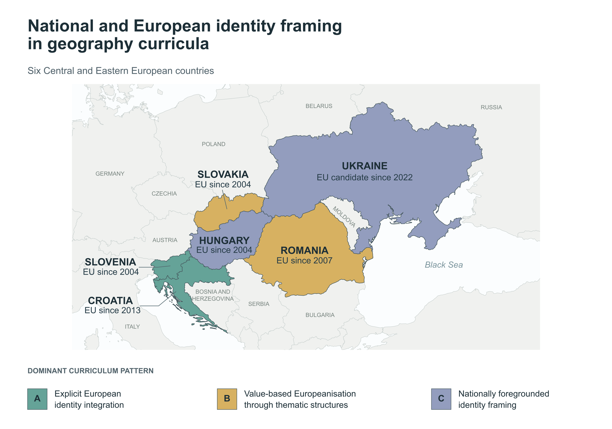
In our new study published in Comparative Education, we examined the official lower-secondary geography curricula (broadly covering pupils aged 10–15, depending on the country) of Croatia, Hungary, Romania, Slovakia, Slovenia and Ukraine. Five are EU members, with accession years shown alongside their curriculum patterns in Figure 1. Ukraine, an EU candidate country since 2022, offers a contrasting perspective.
Colleagues with expertise in the languages and education systems of the six countries analysed national documents using a shared framework. For Ukraine, these included a 2020 state standard, a 2021 typical educational programme and a 2022 model geography curriculum. This matters because the documents straddle a period of profound geopolitical change; our analysis describes their formal content rather than attributing particular wording to those events.
We looked at the sequence of local, national, European and global topics, as well as references to identity, citizenship, values and belonging. The question was how Europe is positioned within each curriculum.
Three broad, partly overlapping, patterns emerged across these formal curriculum documents:
- Explicit European identity integration. Croatia and Slovenia make European identity visible alongside local, regional and national attachments. Their curricula recognise several scales at which people may feel they belong.
- Value-based Europeanisation through thematic structures. Romania and Slovakia foreground cultural diversity, shared challenges, European heritage and the EU. These connections are prominent, though European identity is less consistently articulated as a distinct form of belonging.
- Nationally foregrounded identity framing. Hungary and Ukraine give greater structural prominence to national frames, but for different reasons and without excluding Europe. In Hungary, the curriculum develops attachment to the homeland, national values and the Carpathian Basin – a geographical region extending beyond Hungary’s present-day borders that also serves as a historical and cultural reference point in Hungarian national identity. In Ukraine, national consciousness, statehood and security are prominent, while Europe also appears as a geopolitical aspiration.
The map below brings these patterns together with each country’s EU accession year or candidate status, making the contrast between shared integration histories and different curricular approaches particularly visible.
Same accession date, different curriculum
Slovenia provides the sharpest comparison with Hungary. Their EU membership began on the same day, yet Slovenia’s geography curriculum explicitly presents European belonging within a multi-level identity framework, while the Hungarian curriculum foregrounds national references. Croatia adds a second contrast: despite joining the EU nine years later, its curriculum also integrates European identity explicitly.
This does not mean that Hungarian pupils are taught to reject Europe. The 2020 framework curriculum acknowledges European self-identification and addresses European diversity and EU-related issues. The difference lies in the weight and organisation of its national and European references.
Our earlier research on Hungarian geography curricula and textbooks also documented a declining share of formally allocated European geography content across successive curriculum frameworks, alongside changes in how Europe is represented. That historical comparison provides useful context, although the new six-country study examines currently applicable official documents rather than measuring Europeanisation over time.
The wider point resonates with Clark and Jones’s work on the spatialities of Europeanisation: integration is shaped by territorial histories and political choices. A common EU membership date cannot tell us exactly how Europe will be framed in national education policy.
Why this matters in the geography classroom
School geography offers pupils an organised picture of the world. Maps and curricula make some boundaries, regions and relationships more prominent than others. Saddington and McConnell’s research with primary school pupils in England illustrates how ideas about countries and statehood can become part of young people’s geographical understanding. Nguyen’s review of geopolitics and education likewise reminds us that schooling is intertwined with wider political ideas about territory and the nation.
What the comparison does show is that national and European belonging can be arranged in several ways. They may be explicitly layered, connected through values and cooperation, or organised around a stronger national reference frame. For teachers and curriculum designers, this raises a practical question: how can geography help pupils explore the relationships between places they call home and the wider European spaces to which those places belong?
Europe’s place in school geography is ultimately about more than its location in a sequence of lessons. It concerns the ways geographical knowledge makes relationships between people, places and political communities visible.
About the author: András Béres is a PhD researcher at the University of Pécs, Hungary. His research focuses on the geography of education, spatial inequalities in schooling and the European dimension of geography education.
Further suggested reading
Béres, A., Hont, Z., Resnik Planinc, T., Bockovac, T. A., Végh, A., Kósa, R., Pünkösti, I.-M., Székely, E., Braun, É. and Molnár-Kovács, Z. (2026). Between the nation and Europe: identity framing in lower-secondary geography curricula across six Central and Eastern European countries. Comparative Education. Available from: https://doi.org/10.1080/03050068.2026.2742734
Béres, A., Hont, Z. and Molnár-Kovács, Z. (2025). The European dimension in education in Hungarian primary school geography textbooks. Citizenship, Social and Economics Education. Available from: https://doi.org/10.1177/14788047251318025
Clark, J. and Jones, A. (2008). The spatialities of Europeanisation: territory, government and power in ‘EUrope’. Transactions of the Institute of British Geographers. Available from: https://doi.org/10.1111/j.1475-5661.2008.00309.x
Saddington, L. and McConnell, F. (2025). ‘You could start a new country, but you would need to discover new land’: exploring understandings of statehood with primary school pupils in England. The Geographical Journal. Available from: https://doi.org/10.1111/geoj.70000
Nguyen, N. (2020). On geopolitics and education: interventions, possibilities, and future directions. Geography Compass. Available from: https://doi.org/10.1111/gec3.12500
How to cite
Béres, A. (2026, November) Between the nation and Europe: National and European identities in geography education. Geography Directions. https://doi.org/10.55203/ASMD9074

