
There has been significant academic coverage of the inequitable power dynamics of geographic knowledge production (c.f. Simonsen 2004; Ferenčuhová 2016). By now, we are well-versed in the ways in which some representations and narratives win out over others. We are attuned to the fact that the production of geographic knowledge is also a story of imperialism replete with racialized and gendered processes. Emerging from this scholarship is the notion of a lopsided geography (Friedman 2016) characterized by the starkness of divisions between the core and periphery wherein some places are represented strongly and others remain largely absent. Values and practices continue to be shaped by a Northern research agenda. Additionally, the rich debates and discussions of strategies to decolonize knowledge tend toward the theoretical with few methodological interventions.
In our paper in Geo (http://onlinelibrary.wiley.com/doi/10.1002/geo2.38/full) we attempt to redress some of these inequities by developing a new method for visualizing knowledge production which goes beyond formalized indicators. To illustrate, we chose first to focus on the location of selected dominant critical theories in Geography. By conventionally mapping two sites of theory production (critical GIS and critical urbanism), we demonstrate how normative methods reinforce lopsided geographies by relying narrowly on authorship and scholar affiliation. Our choropleth maps of these two theoretical strands in Geography double as a story of which places are being annotated and who participates in this process. They also illustrate how conventional indicators silence the contexts informing the research. The data is ‘extracted’ in one place (often in the Global South) and ‘processed’ elsewhere (often in the Global North).
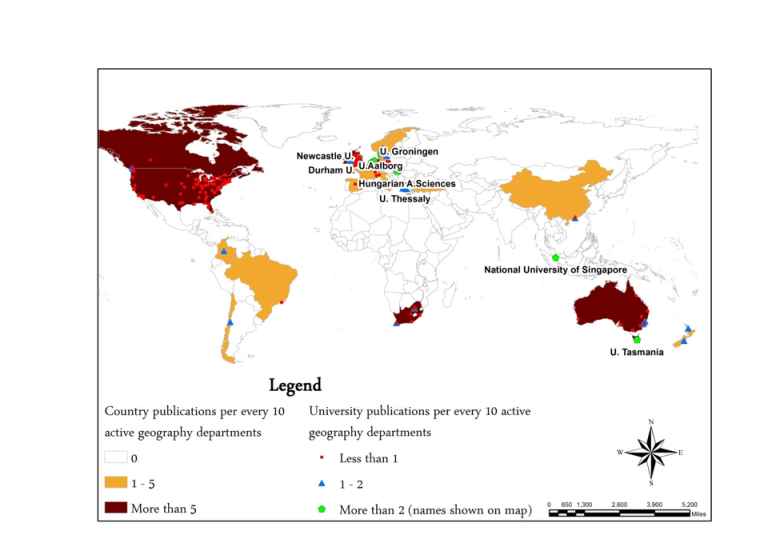
Figure 1 conventionally represents the production of knowledge for critical GIS and critical urbanism (i.e. the number of country publications per every 10 active geography departments). Critical theory, exemplified through these two schools of thought, mainly tends towards ‘Western-centrism’. Production is dominated by the US, Canada, the UK, Australia and South Africa (as the exception). This result, generally, is consistent with our argument that the representation of knowledge through these conventional means suggests a ‘global intellectual divide’.
To get at the heart of the inherent separations embedded in the representation of scholarly research production, we must acknowledge the uneven distribution of value between data production and the generation of theory. The conventional map is in effect a series of bundled components that must be unpacked in order to bring to light the contexts that have generated both the data and subsequent conceptual work. We propose a ‘chromatological’ visualization whereby, just like in Chemistry, we extract the absorbed materials that are not currently visible or acknowledged. The heuristic device of chromatography subjects the product (research, data and knowledge production) to a process of scrutiny which serves to ‘write in’ the separation. In other words, we separate the building blocks of critical geographic scholarship by articulating the absorbed components methodologically.
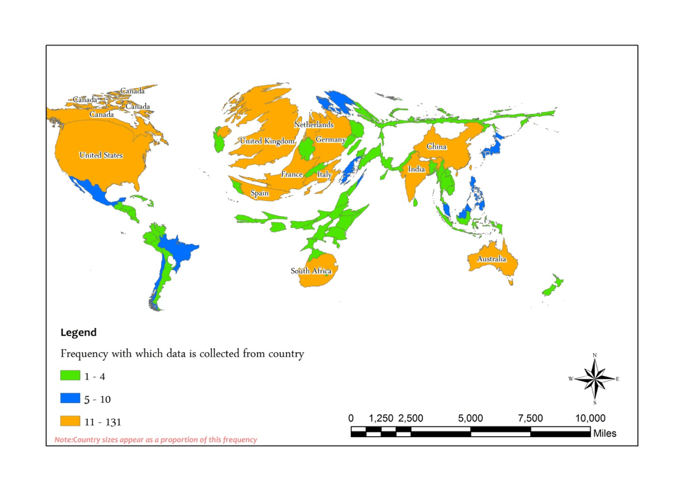
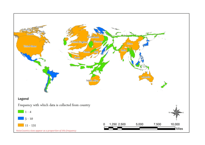
Figure 2 seeks to capture the multiple geographies involved across research processes. Our chromatographical map is based on our review of the publications with more than 50 citations for both critical geography theories. In it, we separated the conceptual and situated (empirically based) publications. Using the situated publications, we developed a table showing the frequency with which a country is used as a field site (i.e. where the researchers gathered their empirical data from and/or made their empirical observations). This counter mapping now shows countries such as India and China conventionally represented as part of the ‘silent side’ of knowledge production.
Our choromatological framework enacts a way of relational thinking currently obscured in discussions of geographic knowledge production. The methodological alternatives described in our work conceptualize actors, field sites, and research products as a multiplicity of inter-scalar interactions. Sites that were formally ‘off the map’ can now be recognized as new generative sites crucial to critical geographic scholarship.
Margath Walker is an Associate Professor in the Department of Geography and Geosciences at the University of Louisville. Emmanuel Frimpong Boamah is an Assistant Professor in the Department of Urban and Regional Planning at the State University of New York, Buffalo
References
Ferenčuhová S 2016 Accounts from behind the curtain: history and geography in the critical analysis of urban theory International Journal of Urban and Regional Research 40 113–31
Friedman U 2016 The lopsided geography of Wikipedia The Atlantic 21 June
Simonsen K 2004 Differential spaces of critical geography Geoforum 35 525–8
