

By Annika Kühn, HafenCity University Hamberg, Hilke Marit Berger, HafenCity University Hamberg, Teresa Erbach, GFZ Helmholtz Centre for Geosciences, Haratua Zosran, freelance artist
Climate adaptation is often framed as a technical task: flood models, risk maps, infrastructure plans. All of that matters. But something important tends to disappear when adaptation is reduced to lines on a map. Everyday life. Memory. Attachment. The kinds of losses people experience long before a shoreline is gone.
Our recent paper, Playful Mapping for Climate Adaptation, grew out of work along Jakarta’s flood-prone northern coast, where climate adaptation, displacement and urban redevelopment collide. We draw on two case studies that emerged from this setting and ask if playful mapping approaches help surface social and cultural values that rarely make it into climate planning.
Play, power and adaptation on Jakarta’s coast
Jakarta’s flooding is not ‘just’ climate change. It is also land subsidence, delayed infrastructure investments, political priorities and long-standing inequality. In North Jakarta, large coastal protection plans have repeatedly relied on authoritative maps showing future embankments, reclaimed land and ‘revitalised’ waterfronts. Often treating kampung neighbourhoods as if they were empty space.
Working in this context made one thing very clear to us: mapping is never neutral. Maps shape what counts as a problem, whose lives are legible and which futures become plausible. Conventional planning maps flatten lived environments into zones and assets. They rarely have a place for memory, emotional attachment, informal routines or community practices. And yet these soft dimensions strongly shape how people experience displacement, and how they adapt.
Here, playful mapping comes into view. Not as a replacement for technical planning, but as a way of widening what mapping can register and what adaptation conversations can hold.
What we mean by playful mapping
By playful mapping, we do not mean entertainment or participation as a box-ticking exercise. We mean creative, experimental practices that treat mapping as a process rather than a product: something done together.
Playful mapping draws on critical cartography, narrative mapping and speculative design. It uses tools such as drawing, storytelling, role-play and game mechanics to open space for dialogue. What interested us here was not playfulness as lightness, but playfulness as a temporary loosening of fixed roles, hierarchies and assumptions. Just enough for other forms of knowledge to surface.
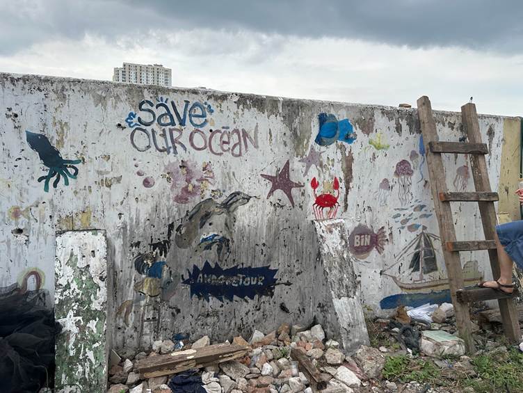
In our study, we examine two such approaches developed within the Sinking Cities research project in Kampung Akuarium, a coastal neighbourhood that was forcibly evicted in 2016 and later partially rebuilt through community-led advocacy.
Case 1: mapping memories with children
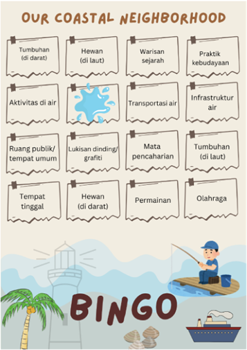
The first case study focuses on Our Coastal Neighborhood, a two-day playful mapping workshop with children aged 11–16. Using flashcards, hand-drawn maps, walking routes and photovoice, we invited participants to recall everyday life before and after the eviction.
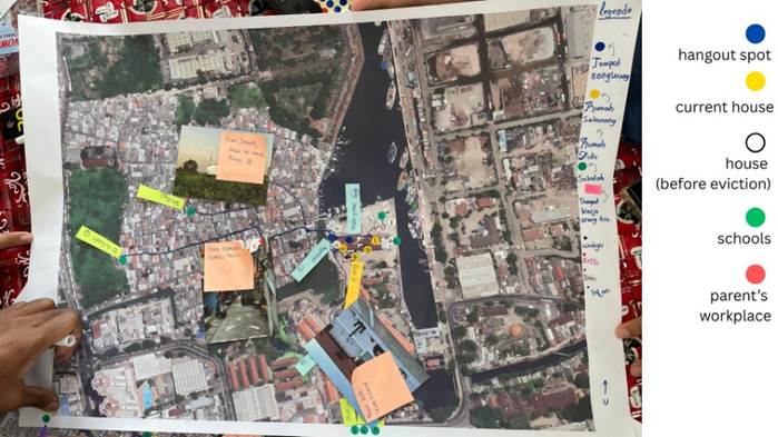
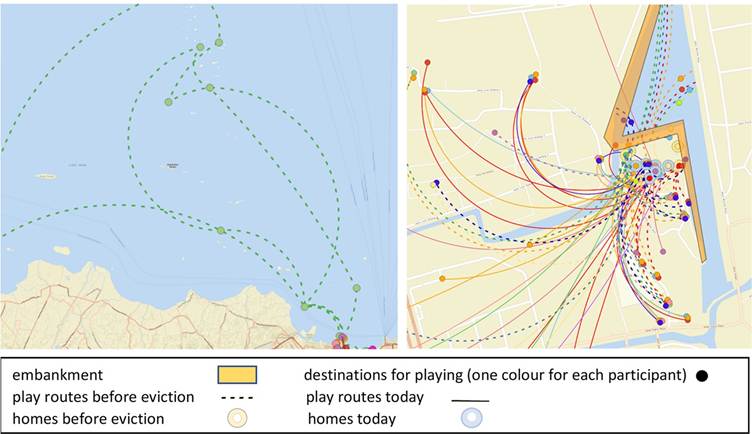
What emerged was an account of loss and disconnection. Children mapped shrinking play areas and blocked access to the sea. Many struggled to recognise practices that adults described as ‘heritage’. A reminder that displacement interrupts not only space, but also intergenerational knowledge.
At the same time, the workshop showed why playful methods can matter in crisis contexts. For children, play is often the most workable way to process disruption. Mapping through drawing, walking and photography created room for experiences that would likely remain invisible in surveys or formal consultations.
The limits were also clear. While the workshop created a shared space for reflection, it did not automatically create a pathway into planning or policy. Without institutional uptake, such mappings risk becoming an archive of memories and of loss, rather than something that can influence decisions.
Case 2: imagining futures through serious gaming
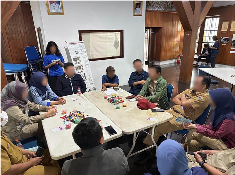
The second case study examines up:town, a role-playing game designed to simulate urban futures under socio-ecological stress. In Jakarta, the game was adapted by local partners and played in two settings: one with kampung residents, and one with government officials and other professionals.
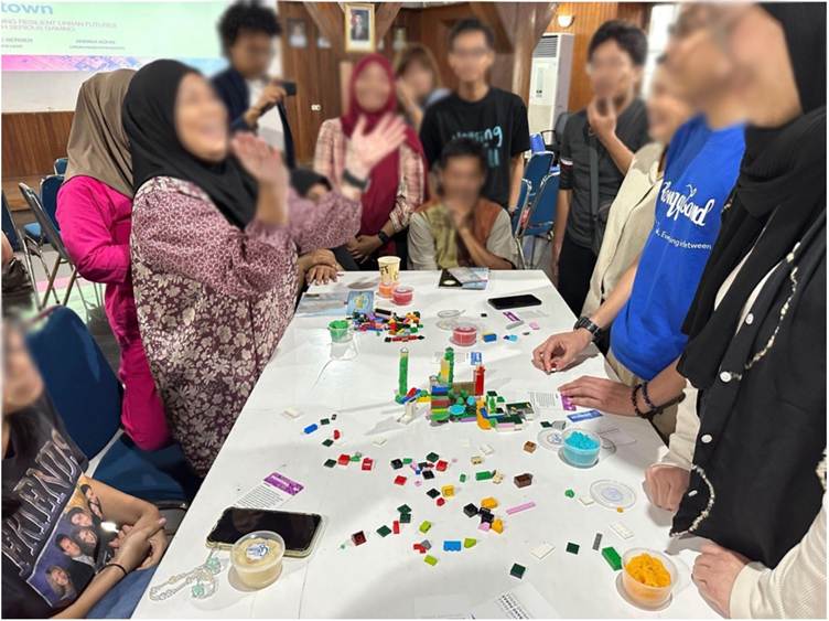
The contrast between these sessions was striking. Among residents, the game sparked lively, imaginative discussions about eviction, resilience and collective futures. Moving between roles allowed people to reframe experiences and, at times, reclaim a sense of agency.
Among professionals, however, the game struggled. Familiar hierarchies resurfaced quickly. Discussions stayed close to technocratic routines. Speculative thinking was constrained by institutional roles and accountability. More than once, the scenario felt simply too close to everyday practice to become properly playful.
This points to a core insight we only fully understood in hindsight: the closer a playful method mirrors lived institutional realities, the harder it becomes to imagine alternatives. Play needs relevance, but it also needs a bit of distance. Without careful facilitation and safe spaces, including for professionals, games risk reproducing the very power dynamics they aim to unsettle.
What playful mapping can (and can’t) do
Across both cases, playful mapping proved powerful in making social and cultural values visible. Values that rarely appear in adaptation plans, but strongly shape how communities experience risk, loss and resilience. Using ‘cultural heritage’ as an open, undefined term allowed participants to articulate what mattered to them, from everyday practices to spiritual and communal routines.
At the same time, playful methods are not inherently transformative. Participation does not equal influence. These approaches are resource-intensive, context-specific and politically fragile. Without long-term commitment and institutional pathways, they risk being dismissed as symbolic, or as ‘nice but irrelevant’.
Why this matters now
As climate impacts intensify, adaptation will increasingly reshape cities, often at the expense of marginalised communities. The question is not whether mapping will be used, but whose realities it will map, and whose futures it will make possible.
Playful mapping will not solve structural injustice. But when it is embedded in long-term, co-creative infrastructures, it can shift what counts as knowledge, whose voices are heard and what kinds of adaptation futures become discussable. In that sense, play is not an add-on to climate adaptation. It is one way of taking its cultural and political dimensions seriously.
*All participants were informed that up:town was part of an academic research project and would be included in related publications. They gave their verbal consent to participate and to the use of the findings. Nevertheless, we have chosen to anonymize all participants in this article to protect their privacy.
The full open-access article, published in Geo: Geography and Environment, develops these arguments in detail and can be read here: https://rgs-ibg.onlinelibrary.wiley.com/doi/10.1002/geo2.70057.
About the authors:
Annika Kühn is a research associate at the City Science Lab at HafenCity University Hamburg, a collaboration with the MIT Media Lab (Cambridge, USA), and a lecturer at the Lucerne University of Applied Sciences and Arts, Switzerland. Her work sits at the intersection of Science and Technology Studies and urban sociology, with a particular focus on creative approaches to knowledge production and collaboration.
Hilke Marit Berger (Dr. phil.) is Scientific Lead of the City Science Lab at Hamburg’s HafenCity University, a cooperation with MIT Media Lab (Cambridge, USA). As an urban researcher, her work at the intersection of cultural studies and urban planning includes practices of collaboration, issues of collective urban design, co-creation in mixed realities and digital art. She leads the “Sinking Cities” project and has a keen interest in artistic research, diversity of methods, and experimental forms of collaboration.
Teresa Erbach conducts research on climate adaptation at the Helmholtz Center for Geosciences (GFZ) in Potsdam and the University Bremen. She is particularly interested in strategies to address the social, cultural and emotional challenges of climate adaptation. Her research is embedded in broader questions of social-ecological transformation and employs transdisciplinary approaches that bridge academic and practice communities.
Haratua Zosran Abednego (he/they) is an early career social researcher focused on issues of climate justice among at-risk children and youth. Haratua’s research covers themes of cultural and epistemic loss following climate-induced disasters. Haratua is also involved in artistic practices which inform creative research approaches, such as games and play. He is currently studying for a Master of Environmental Studies in Victoria University of Wellington, New Zealand.
Suggested further reading
Kühn, A., T.Erbach, H. M.Berger, and H.Zosran. (2026). “Playful Mapping for Climate Adaptation: Two Case Studies From Jakarta’s Coast.” Geo: Geography and Environment. Available from: https://doi.org/10.1002/geo2.70057.
Valette, M., R.Metuktire, J.Mistry, et al. (2026). “Using Participatory Mapping to Strengthen Indigenous Resilience for Wildfire Risk: Lessons From Capoto/Jarina, Brazil.” Geo: Geography and Environment. Available from: https://doi.org/10.1002/geo2.70062.
How to cite
Kühn, A., T. Erbach, H. M. Berger, and H. Zosran (2026, March) Why creative mapping matters in climate adaptation. Geography Directions. https://doi.org/10.55203/THNB8575
